Henderson, Nevada
| Henderson, Nevada | |
|---|---|
| — City — | |
 Location of Henderson in Clark County, Nevada |
|
 U.S. Census Map |
|
Coordinates:  36°2′N 114°59′W 36°2′N 114°59′W |
|
| Country | United States |
| State | Nevada |
| County | Clark |
| Government | |
| • Type | Council/Manager |
| Area | |
| • Total | 94.5 sq mi (244.7 km2) |
| • Land | 94.5 sq mi (244.7 km2) |
| • Water | 0.0 sq mi (0.0 km2) |
| Elevation | 1,867 ft (538 m) |
| Population (2011) | |
| • Total | 260,068 (US: 73th) |
| Time zone | PST (UTC-8) |
| • Summer (DST) | PDT (UTC-7) |
| ZIP codes | 89002, 89009, 89011, 89012, 89014-89016, 89044, 89052, 89053, 89074, 89077 |
| Area code(s) | 702 |
| FIPS code | 32-31900 |
| GNIS feature ID | 0856267 |
| Website | www.cityofhenderson.com |
Henderson is a suburban city in Clark County, Nevada, United States, within the Las Vegas metropolitan area of the Mojave Desert. It is the second largest city in Nevada, after Las Vegas, with a population of 257,729 in the 2010 census.[1] It occupies the southeast end of the Las Vegas Valley at an elevation of approximately 1,330 feet (410 m).
Contents[hide] |
Government
The city received its charter from the State Legislature in 1953 establishing a Council/Manager form of government.
The city is divided into four wards. A mayor is elected city-wide. Four councilmen are elected city-wide, but no more than one councilman can reside in each ward.
Lorna Kesterson was elected as Henderson’s first female mayor, serving two terms until 1993.[2][3] She remains the only woman to serve as mayor to date.[3]
Fire prevention services are provided by the Henderson Fire Department and police services by the Henderson Police Department.
Geography
Henderson is located at 36°2′23″N 114°58′52″W (36.03972, -114.98111).[4]
According to the United States Census Bureau, the city has a total area of 79.7 square miles (206 km2), all land.
As of the 2006, according to the city, the city measured 94.5 square miles (245 km2).[5]
The mountains that surround Henderson mostly have gentle slopes. The McCullough Range is the range closest to the city and most of this range is covered by black rocks from a volcanic explosion millions of years ago. These mountains reach an average height of about 3,800 feet (1,200 m). The landscape consists of desert with barely any water. The only water that is in the city is from washes like Duck Creek.
-

-
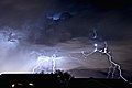
Image of a lightning storm taken from Henderson, Nevada, looking toward the Las Vegas Strip.


Climate
Henderson has mild winters and hot summers. It is one of the driest places in the United States. The state of Nevada is the driest state. Snow can occasionally fall in the winter. The monsoon can bring storms in the summer, like July 3, 2011, bringing floods, thunderstorms, and shutting down traffic lights.
| [hide]Climate data for Henderson, NV | |||||||||||||
|---|---|---|---|---|---|---|---|---|---|---|---|---|---|
| Month | Jan | Feb | Mar | Apr | May | Jun | Jul | Aug | Sep | Oct | Nov | Dec | Year |
| Record high °F (°C) | 75 (24) |
86 (30) |
91 (33) |
97 (36) |
111 (44) |
114 (46) |
117 (47) |
112 (44) |
110 (43) |
100 (38) |
90 (32) |
78 (26) |
117 (47) |
| Average high °F (°C) | 54 (12) |
59 (15) |
67 (19) |
75 (24) |
85 (29) |
95 (35) |
101 (38) |
99 (37) |
91 (33) |
78 (26) |
64 (18) |
54 (12) |
76.8 (24.9) |
| Average low °F (°C) | 41 (5) |
44 (7) |
49 (9) |
56 (13) |
65 (18) |
74 (23) |
79 (26) |
78 (26) |
71 (22) |
60 (16) |
48 (9) |
40 (4) |
58.8 (14.9) |
| Record low °F (°C) | 11 (−12) |
12 (−11) |
25 (−4) |
31 (−1) |
37 (3) |
41 (5) |
56 (13) |
59 (15) |
43 (6) |
30 (−1) |
4 (−16) |
9 (−13) |
4 (−16) |
| Precipitation inches (mm) | 0.70 (17.8) |
0.96 (24.4) |
0.57 (14.5) |
0.23 (5.8) |
0.11 (2.8) |
0.11 (2.8) |
0.46 (11.7) |
0.72 (18.3) |
0.42 (10.7) |
0.36 (9.1) |
0.49 (12.4) |
0.60 (15.2) |
5.73 (145.5) |
| Source: [6] | |||||||||||||
Demographics
| Historical populations | |||
|---|---|---|---|
| Census | Pop. | %± | |
| 1950 | 3,643 | ||
| 1960 | 12,525 | 243.8% | |
| 1970 | 16,395 | 30.9% | |
| 1980 | 24,363 | 48.6% | |
| 1990 | 64,942 | 166.6% | |
| 2000 | 175,381 | 170.1% | |
| 2010 | 257,729 | 47.0% | |
| Est. 2011 | 260,068 | 0.9% | |
| source:[7][8] | |||
According to the 2000 census, there were 175,381 people, 66,331 households, and 47,095 families residing in the city. The population density was 2,200.8 people per square mile (849.7/km²). There were 71,149 housing units at an average density of 892.8 per square mile (344.7/km²). The racial makeup of the city was 80.49% White, 3.76% African American, 0.70% Native American, 3.98% Asian, 0.42% Pacific Islander, 3.16% from other races, and 3.49% from two or more races. Hispanic or Latino of any race were 13.71% of the population.
There were 66,331 households out of which 33.0% had children under the age of 18 living with them, 56.4% were married couples living together, 10.0% had a female householder with no husband present, and 29.0% were non-families. 20.3% of all households were made up of individuals and 5.0% had someone living alone who was 65 years of age or older. The average household size was 2.63 and the average family size was 3.05.
In the city the population was spread out with 25.1% under the age of 18, 7.9% from 18 to 24, 32.5% from 25 to 44, 24.4% from 45 to 64, and 10.1% who were 65 years of age or older. The median age for the city was 36 years. For every 100 females there were 98.4 males. For every 100 females age 18 and over, there were 96.4 males.
The median income for a household in the city was $55,949, and the median income for a family was $61,176. The per capita income for the city was $26,815. About 3.9% of families and 5.6% of the population were below the poverty line, including 6.4% of those under age 18 and 4.7% of those age 65 or over.
Transportation
The city is served by RTC Transit (formerly Citizens Area Transit/CAT) with its network of bus routes which run throughout the Las Vegas Valley.
Henderson is served by four major highways: Henderson black hills and (State Route 582), which is the main thoroughfare connecting with Las Vegas and Boulder City; Lake Mead Parkway (State Route 564);Interstate 515 and Interstate 215. State Route 146, also known as Saint Rose Parkway, connects Interstate 15 near Sloan with Interstate 215 in Green Valley. This stretch is formerly a part of Lake Mead Parkway which is a direct link to Henderson for motorists traveling in and out of Southern California.
Henderson is home for the Henderson Executive Airport. The main airport for the metropolitan area is McCarran International Airport, located northwest of the city.
Street numbering is different within the city of Henderson than with the rest of the Las Vegas Valley. The center of Henderson lies within the intersection of Water Street and Lake Mead Parkway. The Henderson Police Department for years referred to Lake Mead Parkway (and its former name Lake Mead Drive) as “146”, while Boulder Highway is often referred as “93”, its former highway designation.
The Union Pacific Railroad serves Henderson over a branch line originally built to support construction of Hoover Dam. The final few miles of the line, owned by the U.S. Government, were abandoned after the dam was completed. The line still extends to Boulder City; in 1985, the state purchased the section east of appropriately I-515, with the Nevada Southern Railroad Museum operating excursion trains over the easternmost seven miles (11 km).
History OF HENDERSON

The city of Henderson was named in honor of Senator Charles B. Henderson.
Henderson celebrated its 50th anniversary in 2003. The township of Henderson emerged in the 1940s to supply the country with magnesium, the “miracle metal” of World War II.[9] Although “born in America’s defense,” Henderson’s future after the war was uncertain until April 16, 1953, when city incorporation papers were signed.[citation needed]
Henderson was “born in America’s defense” ten years prior to its incorporation during World War II with the building of the Basic Magnesium Plant. The plant supplied the US War Department with magnesium for incendiary munition casings and airplane engines, frames, and other parts. A quarter of all US wartime magnesium came from the Henderson Plant to strengthen aluminum, using 25% of Hoover Dam’s power to separate the metal from its ore by electrolysis.[10] Mayor Jim Gibson’s grandfather, Fred D. Gibson, was one of the original engineers sent to Great Britain to learn the secret of creating the “miracle metal” which would eventually help the United States and the allies win the war. However, in 1947, magnesium production was no longer necessary for defense, and most of the 14,000 BMI employees moved away. Enrollment in the school system was reduced by two thirds and well over half the townsite houses, built to house plant workers, went vacant. In 1947, the United States War Asset Administration actually offered Henderson for sale as war surplus property.[citation needed]
In an effort to save the city, the Nevada Legislature spent a weekend visiting Henderson evaluating the possibility of state administration of Basic Magnesium. Within days of the visit, the legislators unanimously approved a bill giving the Colorado River Commission of Nevada the authority to purchase the industrial plants. Governor Vail Pittman signed the Bill on March 27, 1947, helping save Henderson from becoming war surplus property.
With the help of local industry, the city of Henderson, Nevada, was officially incorporated on April 16, 1953. On May 23, 1953, Henderson, with its population of 7,410, elected Dr. Jim French as the town’s first Mayor. Originally about 13 square miles (34 km2) in size, the city quickly began to grow and flourish. Today, Henderson has grown to 94 square miles (240 km2) and is the second largest city in Nevada. The city’s official slogan “Henderson–a Place to Call Home” reflects a community that enjoys small town values while benefiting from big city efficiencies.
An increasing number of major shopping malls, movie theater complexes, restaurants and casino resorts offer residents a variety of choices for leisure time in Henderson. The city also borders Las Vegas and is not too far from the world-famous Las Vegas Strip. “Shakespeare in the Park” celebrated its tenth anniversary in 1996, a testament to Henderson’s long standing support for the arts and cultural programs. The city also boasts the largest recreational facility – the Multigenerational Facility at Liberty Pointe – in Nevada as well as Nevada’s only scenic Bird Preserve. The city supports a variety of other cultural events as well, many of which are held at the outdoor amphitheater, the largest one of its kind in Nevada.
Henderson is located just a few miles from McCarran International Airport; and Henderson Executive Airport, recently acquired by Clark County, is planned for major renovation and development as a reliever airport to McCarran.
Master-planned residential areas include Anthem, Anthem Country Club, Black Mountain Vistas, Calico Ridge, Champion Village, Green Valley, Green Valley Ranch, Inspirada, Lake Las Vegas, MacDonald Highlands, MacDonald Ranch, Madeira Canyon, Seven Hills, Sun City Anthem, Sun City MacDonald Ranch, Tuscany Residential Village, and Whitney Ranch.
| Service | Mayor |
|---|---|
| 1953-1957 | James B. French |
| 1957-1965 | William B. Byrne |
| 1965-1969 | William R. Hampton |
| 1969-1973 | Estes M. McDoniel |
| 1973-1975 | Cruz Olague |
| 1975 | Richard A. Stewart, Sr. |
| 1975-1981 | Lorin L. Williams |
| 1981-1985 | Leroy Zike |
| 1985-1993 | Lorna J. Kesterson |
| 1993-1997 | Robert A. Groesbeck |
| 1997-2009 | James B. Gibson |
| 2009-present | Arthur Hafen |
Rocket fuel factory fire
In 1988, the PEPCON rocket fuel factory became engulfed in fire. There were multiple explosions, causing some earthquakes, some measuring over 3.0 on the Richter magnitude scale. Two people were killed. The explosion spurred the development of Henderson from industrial to the largely residential area it is today. There are no signs of the Pepcon explosion today, and the site now consists mostly of office buildings.
The 20th Best Place to Live
In 2006, Money magazine ranked Henderson 20th in its annual list of the top 100 places to live in the U.S.[11]
In 2012, Henderson was ranked 66th. http://money.cnn.com/magazines/moneymag/best-places/2012/states/NV.html
Hiking trails
Prevention magazine tapped Henderson in 2007 as the sixth best walking city in America, ahead of San Diego, California, and just behind Seattle, Washington.[dead link][12] Henderson has more than 37 miles (60 km) of trails.[13]
Film history
- Henderson is frequently featured on the TV drama, CSI: Crime Scene Investigation as the location of residence of a victim or other person of interest, although the majority of the show’s filming takes place in California.[citation needed]
- The documentary Real CSI” featured the Henderson Police Department (HPD) Crime Scene Analysts/Investigators.
- A scene in the James Bond film Diamonds Are Forever in which Bond (Sean Connery) is nearly cremated alive was filmed at Palm Mortuary’s Henderson location. Later in the movie he is dumped into a pipeline, which was filmed near Trailer Estates on Lake Mead Boulevard. The construction office for the Lake Mead to Las Vegas Water pipeline was located there during the building of the pipeline and the filming of the movie.[citation needed]
- America’s Sweethearts, starring Julia Roberts and John Cusack, featured many scenes filmed at Lake Las Vegas.[citation needed]
- Paranormal Activity 4 takes place in Henderson.
Economy
Top employers
According to the City’s 2010 Comprehensive Annual Financial Report,[14] the top employers in the city are:
| # | Employer | # of Employees |
|---|---|---|
| 1 | City of Henderson | 2,963 |
| 2 | St. Rose Dominican Hospital – Siena Campus | 1,000-1,499 |
| 3 | Green Valley Ranch | 1,000-1,499 |
| 4 | M Resort | 1,000-1,499 |
| 5 | Sunset Station | 1,000-1,499 |
| 6 | Medco Health Solutions | 800-899 |
| 7 | St. Rose Dominican Hospital – Rose de Lima Campus | 800-899 |
| 8 | Zappos.com | 600-699 |
| 9 | Walmart | 600-699 |
| 10 | Fiesta Henderson | 500-599 |
Media
Newspapers
Television
KVVU is licensed to broadcast from Henderson as Fox News.
Some notable residents
- Glen and Les Charles, creators of Cheers and Taxi.[15]
- Celine Dion (born 1968), Canadian pop singer [16]
- Flavor Flav (born 1959), rap music artist and reality television personality[17]
- Brandon Flowers (born 1981), vocalist for The Killers[18]
- Pierre Omidyar (born 1967), CEO and Founder of eBay Inc. [19]
- Austin “Chumlee” Russell, reality television personality known as a cast member on the History TV series Pawn Stars[20]
- David Sklansky (born 1947), professional poker player/author[21]
- Nancy Walton Laurie (born 1952), daughter of Walmart co-founder James “Bud” Walton[22]
Education
The Clark County School District provides elementary and secondary public education. Henderson is the location for 29 elementary schools, nine middle schools, and nine high schools. Five of the nine high schools are public schools. A tenth high school, Silverado High School, also serves parts of Henderson but is located in the unincorporated Clark County (Paradise).
Colleges and universities
Henderson is home to several colleges and universities. Nevada State College, a baccalaureate college in the Nevada System of Higher Education. The Roseman University of Health Sciences, a private university which awards degrees in nursing, pharmacy, and business, is located in Henderson. The College of Southern Nevada, a community college based in Las Vegas, maintains a branch campus in Henderson. California’s National University and Touro University Nevada also maintain a campus in Henderson.
Several for-profit colleges also operate in the city, including The Art Institute of Las Vegas, Everest College-Henderson formerly Las Vegas College, and the Nevada branch of the ITT Technical Institute.
Nevada State College
Founded in 2002 on a 509-acre (2.06 km2) site in the southern foothills of Henderson, Nevada State College offers academic programs regular and accelerated nursing degrees, education degrees, and liberal arts majors including psychology, biology, history, English, criminal justice, and an Occupational Therapy joint degree program in conjunction with Touro College. Its first permanent building, the Liberal Arts and Sciences building, opened in August 2008. Nevada State College’s full-time faculty is 34.2% ethnic/racial minorities, which is the highest percentage of all colleges of the Nevada System of Higher Education institutions. The college realized accreditation through the efforts of its late President Dr. Fred Maryanski.
Select points of interest
- Acacia Demonstration Gardens
- Anthem Country Club
- Art Galleries
- Black Mountain Recreation Center
- Museum
- Ethel M Botanical Cactus Garden
- Ethel M Chocolate Factory
- Galleria at Sunset
- Seven Hills Estates
- Green Valley Ranch Resort, Spa, and Casino
- The District at Green Valley Ranch
- Fiesta Hotel
- Henderson Bird Viewing Preserve and Water Reclamation Facility
- Henderson Pavilion Concert Theater and Recreational Plaza
- Lake Las Vegas
- Lamborghini Las Vegas showroom
- Loews Resort at Lake Las Vegas
- M Resort
- MacDonald Highlands
- Montelago Village and Boutiques
- Nevada State College
- Ravella at Lake Las Vegas
- Sunset Station Hotel
- Veteran’s Wall
- Wildhorse Golf Club
See also
References
- ^ http://www.city-data.com/us-cities/The-West/Reno-Population-Profile.html
- ^ McMurdo, Doug (2012-01-17). “Former Henderson mayor Lorna Kesterson dies at 86”. Las Vegas Review-Journal. Retrieved 2012-01-20.
- ^ a b Zvosec, Carla J. (2012-01-18). “City’s first and only female mayor dies at age 86”. Henderson Press. Retrieved 2012-01-20.
- ^ “US Gazetteer files: 2010, 2000, and 1990”. United States Census Bureau. 2011-02-12. Retrieved 2011-04-23.
- ^ http://www.visithenderson.com/visit/glance/history/ visithenderson.com
- ^ “Monthly Averages for Henderson, NV”. Weather.com. Retrieved November 21, 2011.
- ^ Moffatt, Riley. Population History of Western U.S. Cities & Towns, 1850-1990. Lanham: Scarecrow, 1996, 156.
- ^ Table 3. Annual Estimates of the Resident Population for Incorporated Places in Nevada: April 1, 2010 to July 1, 2011
- ^ Lelande Quick, Miracle Metal from Nevada Hills, Desert Magazine, June 1944, pages 10-13
- ^ Moore, David. The Hoover Dam: A World Renowned Concrete Monument Roman Concrete, 1999. Accessed: 26 February 2012.
- ^ “MONEY Magazine: Best places to live 2006: Henderson, NV snapshot”. CNN. Retrieved 2010-05-04.
- ^ Top 100 Best Walker-Friendly Cities – Prevention.com[dead link]
- ^ Lyle, Michael (May 15, 2008). “Battle-born Henderson now ‘A Place to Call Home’”. Las Vegas Sun.
- ^ City of Henderson Comprehensive Annual Financial Report
- ^ [1]
- ^ [2]
- ^ Flavor Flav and ‘Flavor of Love’ winner Nikki Alexander “just friends”
- ^ McLean, Craig (2006-09-24). “Songs of praise”. The Guardian (London). Retrieved 2010-05-04.
- ^ http://virtualglobetrotting.com/map/pierre-omidyars-house/
- ^ Harrison, Rick; Keown, Tim; Russell, Austin. License to Pawn: Deals, Steals, and My Life at the Gold & Silver 2011. Hyperion Books. New York. ISBN 978-1-4013-2430-8. Page 203.
- ^ 72os.com – Poker League, Poker Community – David Sklansky – Player Profile
- ^ Las Vegas Bus